Chistochina area has brief but rich gold rush history
 |
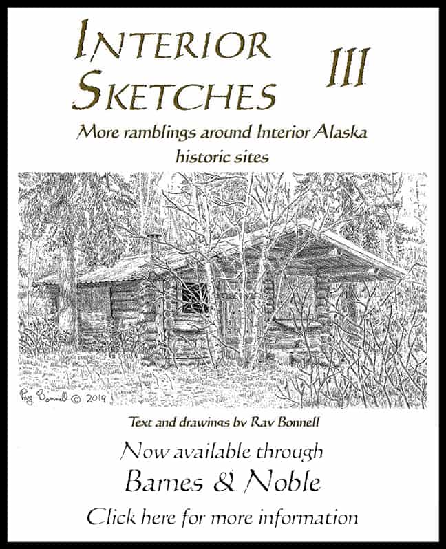
| This historic cabin is one of the few remnants of the Chistochiona Trading Post, which burned down in 1999 |
Gold was discovered along the Chistochina River in late 1898 by argonauts originally headed for the Klondike gold fields via the Valdez Glacier Trail.
Between 4,000 and 5000 gold seekers attempted the treacherous trail over the Valdez and Klutina glaciers and down the Klutina River to Copper Center in the Copper River Basin. Only a fraction succeeded. Many who did were ill-equipped to proceed, losing most of their supplies to the glacier crossing or along the tumultuous Klutina River.
Few gold seekers had the will to continue on to the Klondike, and only a handful completed the trip. Others returned to Valdez. The rest fanned out across the region in search of new opportunities.
George Hazelet and his party were a few of the fortunate ‘98ers who made it to Copper Center. Befriended by an Ahtna Athabascan guide, they became the first prospectors along the Chistochina River. In early winter of 1898-99 they struck paydirt on the Chisna River, near the Chistochina’s headwaters.
The Upper Chistochina is inhospitable to placer mining‚ with no road access, inclement weather, brief summers and undependable water supplies. Emil Goulet mined in the area during the 1930s and wrote in his book, Rugged Years on the Alaska Frontier, that snowpack had to be excavated before mining could commence, that being wet and cold was the normal state of being during the mining season, and that miners could expect snowstorms any time after Sept. 1.
Copper Center was 100 miles south of the Upper Chistochina mines. The hamlet of Chistochina, near the confluence of the Chistochina and Copper Rivers, grew into the closest community. A 1902 U.S. Geological Survey map of the area does not indicate any settlement there, but does show the Valdez-Eagle Trail along the north bank of the Copper River just south of Chistochina’s present location, and the Washington-Alaska Military Cable and Telegraph System (WAMCATS) lines about two miles to the north.
According to National Register of Historic Places documents, Ahtna Athabascan Indians, who had previously utilized a seasonal fish camp in the vicinity, established a permanent village at Chistochina in 1903 (The area’s population is predominantly Ahtna, and the Chistochina Native village is still in existence. The village is governed by the Cheesh’na Tribal Council.)
Also in 1903, a Washington-Alaska Military Cable and Telegraphy System (WAMCATS) telegraph station was constructed nearby. Wireless telegraphy replaced WAMCATS landlines by the 1920s, and one of the first sections of line to close was the one from Gulkana to Eagle. That section, including Chistochina’s telegraph station, was abandoned in 1911.
Chistochina probably would have remained a tiny Native village had it not been for a new gold mine opening during the 1920s at Nabesna, 70 miles to the east. To reach Nabesna, the Alaska Road Commission (ARC), beginning in 1926, upgraded the trail from Gakona to Slana into a wagon road, and in 1933 began work on a road from Slana to Nabesna. By 1932, the ARC, which was also responsible for civilian airfield construction in Alaska, had built a landing strip at Chistochina. This strip was used by Bush pilots, including Bob Reeves, to fly supplies into Chistochina, Nabesna and Chisana gold camps.
Chistochina is about mid-way between Gakona and Slana and was a convenient stopping point for freighters headed to Nabesna. Sometime in the mid-1920s or early 1930s (sources differ), Chistochina Trading Post was established. Over time, the trading post morphed into a roadhouse — comprised of a long 1½-story log structure with numerous additions that housed café, bar, and bunkhouse, plus outbuildings.
Unfortunately, the trading post burned to the ground in November 1999. A new establishment, the Red Eagle Lodge, replaced it. The cabin shown in the drawing, now used for guest housing, was one of the trading post’s outbuildings. According to the Red Eagle Lodge’s owners, Richard and Judy Dennis, the 18-foot by 20-foot log cabin, with dove-tailed corners and simple gable roof, still retains its original cabin logs and front-porch decking. It is one of the oldest structures on the site.
Sources:
- “Chistochina Trading Post – National Register of Historic Places Registration Form.” Deborah A. Smith & Joan M. Antonson. National Park Service. 1997
- Conversation with Richard Dennis, co-owner of Red Eagle Lodge
- Icebound Empire, Industry and Politics on the Last Frontier 1898-1938 . Elizabeth A. Tower. Old Stone Press. 2015
- Rugged Years on the Alaska Frontier. Emil Oliver Goulet. Dorrance & Company. 1949
- “Topographic reconnaissance map of the Central Copper River Region, Alaska.” T.G. Gerdine. U.S. Geological Service. 1902


